Mapping Our Urbanism Part III – Water Mains
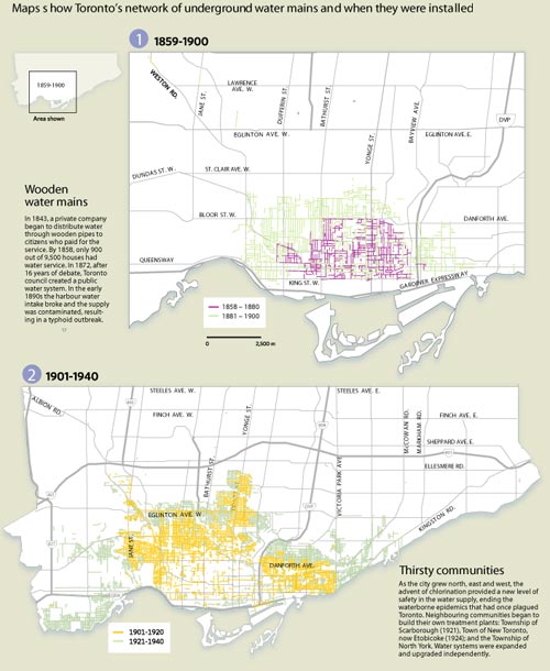
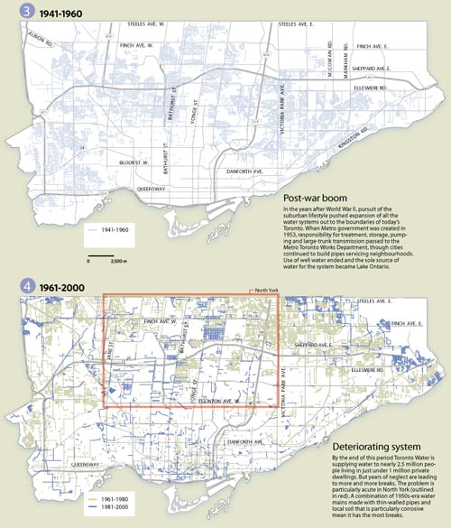
In the Toronto Star last weekend was a special 2-page spread on the sorry state of Toronto’s water mains with emphasis on who’s to pay for upgrades (see story online here). However, the maps included give a fascinating glimpse into the history of Toronto’s development seen through the age of the water mains. Divided into four periods, 1859-1900, 1901-1940, 1941-1960, and 1961-2000, these maps are indispensable for anyone interested in the history of urban infrastructure. To see a little more detail, follow these links (maps 1+2, maps 3+4) – if you prefer a much more detailed PDF version of the maps is available from the Star’s site here (PDF).
Crossposted to the Spacing Wire


3 Comments so far
Leave a comment
[…] Mapping our urbanism part III – water mains […]
By Bricoleurbanism » Mapping Our Ubanism Part IV - Language on 12.30.07 5:26 pm
[…] Mapping our urbanism part III – water mains […]
By Bricoleurbanism » Mapping Our Urbanism Part V - Watersheds on 01.13.08 9:59 pm
[…] Mapping our urbanism part III – water mains […]
By Bricoleurbanism » Mapping Our Urbanism Part VI – Income on 11.25.09 10:43 am
Leave a comment
Line and paragraph breaks automatic, e-mail address never displayed, HTML allowed:
<a href="" title=""> <abbr title=""> <acronym title=""> <b> <blockquote cite=""> <cite> <code> <del datetime=""> <em> <i> <q cite=""> <s> <strike> <strong>